Snow melting steadily in Colorado’s mountains, combined with a soppingly wet May and early June, has left water storage reservoirs relatively full and rivers flowing at normal or higher-than-normal levels, easing drought anxieties.
The rain falling regularly across metro Denver and the high plains brought near-record moisture, which has saturated soils to the point they are primed for flooding. And vegetation in cities and farm fields is thickening. This means reduced demands for water that, in typical years, draw down reservoirs. Denver Water officials this week ramped up releases from the 96% full Dillon Reservoir through its dam into the Blue River, a tributary of the Colorado River. The utility officials touted benefits for fish, other aquatic life and possibly people who want to go rafting.

National Weather Service data on rainfall from May 1 through June 6 shows the following totals:
- Castle Rock with 12.07 inches
- Centennial with 10 inches
- Aurora with 10.8 inches
- Denver with 8.19 inches
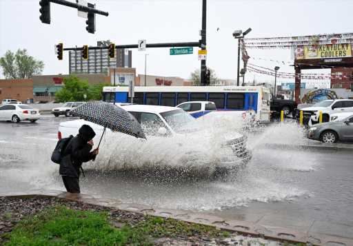
- Colorado Springs with 6.86 inches
- Estes Park with 6 inches
- Fort Collins with 8.94 inches
- Greeley with 8.88 inches
- Limon with 7 inches
- Sterling with 7 inches
- Dillon with 4 inches
“The largest amounts fell in the northeastern section of Colorado,” NWS meteorologist Caitlyn Mensch said. “If you go south, it trends slightly drier. If you go westward, it trends a little less.”
Despite all that rain, the damage from flooding has been relatively manageable.
“We’ll see how this next week shakes out. There’s still a lot of moisture in the air,” state climatologist Russ Schumacher said Thursday afternoon. “For the most part, we’ve avoided really major flash floods along the Front Range. But we will have to keep an eye out, especially over the fire burn scars. A heavy storm that ends up in the wrong spot could lead to some bad situations,” he said.
“It has been mostly good news around here this spring. We’ve had lots of moisture but we haven’t had any really big flood disasters – at least not yet. The snow melting in the mountains has stayed well-behaved. It didn’t all come down at once.”
Reservoir water levels this week measured higher than the 1981-2021 average, according to federal data. In the north-central mountains, the Lake Granby reservoir measured 131% of the average. Blue Mesa Reservoir, severely depleted in recent years, measured 78% full, 114% of the average. Similarly, McPhee Reservoir, in southwestern Colorado, measured 113% of the average and Navajo Reservoir was at 96%.
Mountain snowpack, mostly above normal this spring, plays the main role in filling reservoirs as the snow melts and water trickles down into streams that feed rivers.
River water levels around Colorado this week measured normal and in some cases above normal.
U.S. Geological Survey gauge data showed “much above normal” flows in the Yampa River (about 4,000 cubic feet per second at Steamboat Springs) and the Colorado River (about 40,000 cfs at the Utah state line). Robust normal flows also were recorded in the Gunnison River (about 5,000 cfs near Gunnison), Animas River (4,000 cfs at Durango), South Platte River (2,000 cfs at Fort Morgan), and Arkansas River (2,100 cfs east of Pueblo at Avondale).
Meanwhile in the Pacific Ocean, warming currents detected by National Oceanic and Atmospheric Administration sensors may lead to increased moisture in Colorado later this year. NOAA officials on Thursday issued an El Niño advisory as scientists tracked these currents, which affect weather around the planet. Colorado climate researchers anticipate the warming could lead to more rain during late summer and fall in eastern Colorado where farmers in recent years have suffered from hot and bone-dry conditions.
Get more Colorado news by signing up for our Mile High Roundup email newsletter.
Source: Read Full Article
-
Drug-dealing doctor who named himself 'Stormtrooper' is jailed
-
Putin deploys 11 nuclear bombers just 20 miles from Nato border as Russia warns of apocalyptic World War 3 | The Sun
-
‘It’s not right!’ EU row erupts as Scholz slapped down in heated spat on Russia travel ban
-
Steve Barclay told to make cuts to existing budget for NHS salary hike
-
Huge explosion rips apart Pennsylvania chocolate factory killing two